


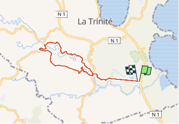
La Trinite - Boucle Le Galion

Lamartiniere
User GUIDE

Length
10.9 km

Max alt
136 m

Uphill gradient
172 m
Km-Effort
13.2 km

Min alt
8 m

Downhill gradient
172 m
Boucle
Yes
Creation date :
2016-03-09 00:00:00.0
Updated on :
2016-03-09 00:00:00.0
3h06
Difficulty : Unknown

FREE GPS app for hiking
 SityTrail
IGN / Geographical institutes
SityTrail Plus
The world is yours!
About
Trail Walking of 10.9 km to be discovered at Martinique, Unknown, La Trinité. This trail is proposed by Lamartiniere.
Description
bonne rando
Positioning
Country:
France
Region :
Martinique
Department/Province :
Unknown
Municipality :
La Trinité
Location:
Unknown
Start:(Dec)
Start:(UTM)
720794 ; 1628117 (20P) N.
Comments